| About |
| Screenshots |
| Download |
| Installation |
| Usage |
| User support |
| Summary |
| Science |
| Donate |
| Email me |
Introduction
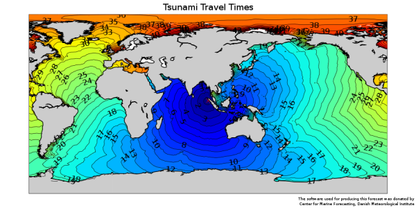
Simple Long Ocean Wave Model (slowmo) is used for calculating tsunami travel times. When a tsunami is created the application can be run to produce a map showing when the tsunami will hit nearby coastlines. The application can be executed locally or it can be run as a web server allowing the program to be accessed through a web browser. You can try it out here.
(Click here for a larger image)
It is also possible to use this method to make a backward calculation where a specific location is selected. A map containing travel times from an arbitrary point to the point you have selected is then produced. Once the origin of a tsunami has been established you can then see from the travel times map how long it will take for a tsunami to reach the position you have made the map for.
Method
The calculation is based on the fact that the wave length of a tsunami is very long compared to the depth of ocean. This means that the phase speed of the tsunami is given as the square root of gravity times ocean depth. Furthermore we can apply Huygen's principle which states that all points the wavefront are point sources for secondary spherical waves. In plain english this means that a tsunami wavefront will take the quickest route from the origin of the wave to a given point (wave fronts taking longer routes may also arrive at the point at a later time). The only input needed for this type of calculation is a digital bathymetry (ocean depth map). Slowmo includes the ETOPO5 bathymetry which is available from the National Geophysical Data Center, National Oceanic and Atmospheric Administration, U.S. Department of Commerce.
The application assumes that the tsunami originates from a single point. In reality a tsunami can be created along a rift in the ocean floor. In this case the calculation will have an error due to misspecification of the tsunami origin.
Acknowledgements
The idea for this application and the theory behind originates from this West Coast & Alaska Tsunami Warning Center website where you can also find further scientific references. So thank you guys and girls at West Coast & Alaska Tsunami Warning Center.
I made the original version of this application for a tsunami risk assessment report at the Danish Meteorological Institute (DMI). DMI kindly allowed me to use this original code as a basis for the further development and publication of slowmo. This development has been done in my spare time. The acknowledgement of DMI on this web site and on the plots should therefore not be seen as a DMI endorsement of slowmo.
Disclaimer
This software is experimental and is released without any warranty. The author takes no responsibility for any damage to property, health or life caused by this software. If you are going to use this software for tsunami warning purposes please take steps to ensure the quality of the prognosis before deploying it.
Other projects
World Wild Weather is a web site that provides world wide marine forecasts for sailors, surfers, fishermen and other people at sea.
NetCDF web is a tool for simple web presentation of NetCDF files.